TÜRKİYE ÜZERİNDE YER GÖZLEM VERİLERİYLE İYİLEŞTİRİLMİŞ YÜKSEK ÇÖZÜNÜRLÜKLÜ HOMOJEN RADAR YAĞIŞ HARİTASI ELDE EDİLMESİ
ESTIMATION OF HOMOGENEOUS HIGH-RESOLUTION RADAR BASED PRECIPITATION MAP IMPROVED USING STATION BASED OBSERVATIONS OVER TURKEY
Funding Agency (Destekleyen Kuruluş): TUBITAK 1001, Grant No 117Y118
A comprehensive radar network consisting of 17 C-band meteorological weather radars located over various regions have been installed in Turkey. The goal of this study is to analyze and develop various methodologies available in the literature, consisting of hourly gauge adjustment (MFB, LMB, LAB, LMIB) and time-independent bias correction (MLR, ANN, CDF, Z-R) and validate them on the radar network as a whole and over a long-term period.
The radar-based estimations were initially compared against about 1100 AWOS rain gauge observations. Furthermore, the performance of various bias correction methods, including gauge adjustment and time-independent methodologies, were cross-validated using independent validation gauges. Accordingly, a composite map of both raw and statistically corrected radar data was composed based on all correction algorithms. The accuracy of this composite map was tested using 50 Triple-Collocated rain gauge stations over various regions. Finally, the accuracy of the corrected radar-based estimations was compared both seasonally and spatially over a long-term period. These analyses were followed by choosing a consistent methodology with the highest accuracy in producing a high-resolution radar-based precipitation map. The high-resolution precipitation maps produced in this study can be obtained from GDM. These maps will be a critical input in many future studies, such as the operational prediction of flash floods. Therefore, this research provides a significant contribution to the hydrology, meteorology, and water resources communities.
In the initial investigation of radar-based precipitation estimates, the radar estimations obtained from the majority of the radars have shown a generally good correlation (0.45-0.6) with the gauge-based observations (disregarding the time, location, and type of precipitating event). The lowest COR values belong to KRM, ERZ, and SRF. Most radars have an RMSE value between 2-4 mm/hr. KRM has the highest RMSE (near 10mm/hr). This shows there is a significant difference in this radar compared with the statistics of other radars, which could be due to hardware (e.g., transmitter malfunction) problems.
The most substantial limitation in the majority of the radars was shown to be the underestimation, which can happen due to beam blockage in regions with complex topography. In the scatterplots (Figure 3.48-3.54), it was shown that the underestimation rate is intensified in heavy rather than light precipitation events. An overall review of ME values indicates the underestimation of radars against ground observations in all radars except KRM and ERZ. The effect of beam blockage was investigated by measuring CBB-AV, which is the average CBB obtained from all elevation angles associated with each radar. It was shown that higher CBB-AV results in lower percent biases, thus increasing the underestimation errors in radar-based estimations. Therefore, we used this parameter as a quality control factor in the final composite map and filtered out the radar-based estimations associated with CBB-AV of higher than 30%. Consequently, in the overlapping areas between two radars, the composite map uses the estimations from the radar, which has a CBB-AV rate of lower than this threshold. In overlapping areas where none of the radars pass this filter, the gauge-based observation interpolation is replaced in the composite map. CBB parameter was also used in measuring Hvmin, which was used as input in ANN and MLR models. Both the CBB-AV and Hvmin maps generated for the radar network in Turkey can be useful for operational decision making.
The relative performance of the bias correction methods was validated using four error statistics (ME, RMSE, COR, and ESD) over training and validation datasets using data obtained over five years (2014-2018). Confidence about the results obtained and selection of the best method among all methods was developed owing to the consistency of the error metrics over all mentioned datasets. The most significant difference in the performance of gauge adjustment and time-independent bias correction methods is the ability of the first set of methods to suppress the random errors. Although time-independent methods are stationary and do not change over time similar to gauge adjustment methods, they have shown to outperform simple field-based gauge adjustment method (MFB). Overall, local additive assumption of error distribution, LAB has shown to yield the best results among all eight methods by performing better in 16 out of 17 radars disregarding the season and type of precipitation. Based on results obtained from training and validation datasets, LAB can be reliably used as a reference method for improving the accuracy of radar-based estimates using the gauge-based observations in all radars situated in Turkey.
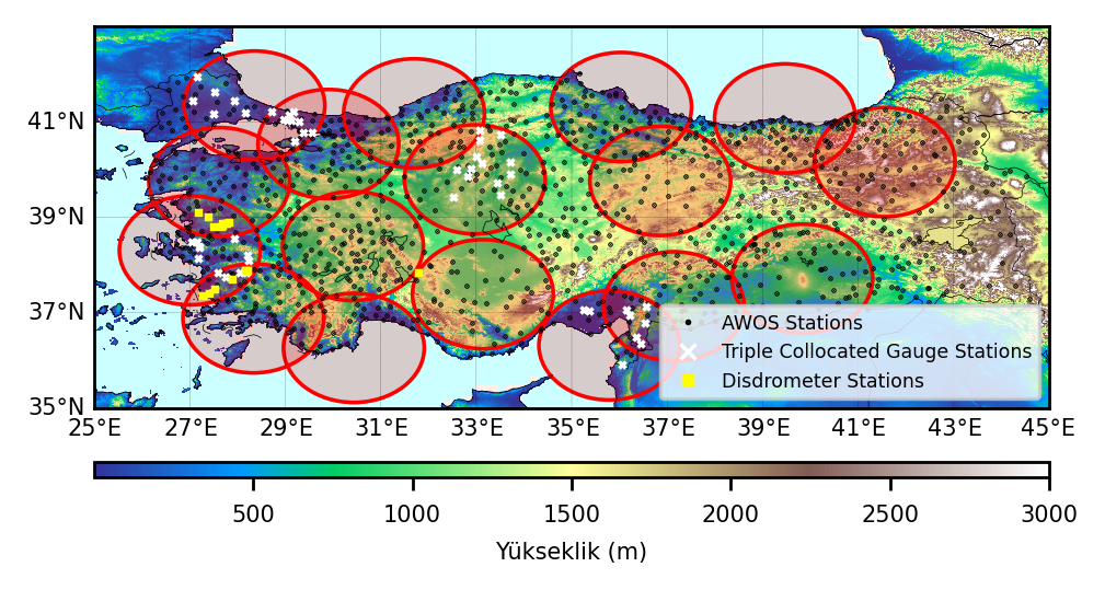
AWOS, Triple-Collocated, optical disdrometers stations, and the C-band meteorological weather radar locations plotted over digital elevation map over Turkey. The range of radars is 120 km.
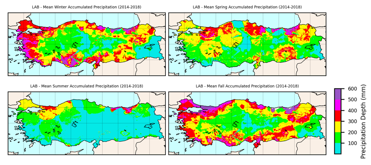
Seasonal interpolated composite maps for Local Additive Bias (LAB) corrected radar estimations
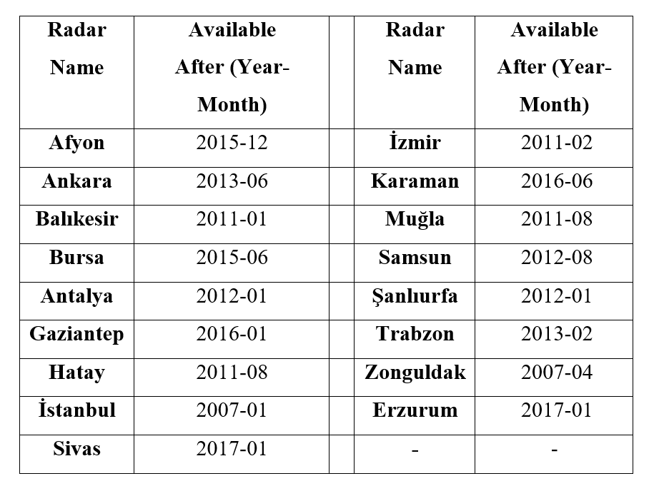
Availability of Radar Data