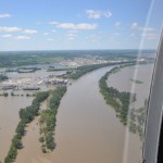
 Historic flooding in the Midwest along the Missouri River occurred in the sum-mer of 2011. According to the National Weather Service, the flooding was due to a combination of an estimated 212 percent of nor-mal snowpack in the Rocky Mountains and nearly a year’s worth of rainfall in the upper basin of the Mis-souri river during the second half of May. The flood devastated homes, businesses and many square miles of farmland in Montana, North Dakota, South Dakota, Iowa, Nebraska, Missouri and Kansas. The Fort Calhoun and Cooper nuclear stations are located in the flooded region. Both plants took precautions to implement and bolster flood protection measures and ensure safety would be maintained as water lev-els rose.
Fort Calhoun had shut down for a scheduled refuel-ing outage before the flood. It remains in a safe shutdown condition pending NRC permission to re-start. Flood protection measures included sandbags, aqua berms and additional testing of emergency die-sel generators and loss of off-site power procedures. The NRC detailed additional inspectors to Fort Cal-houn during the peak of the flood, and NRC Chair-man Gregory Jaczko visited the plant to view the flood protection measures.
Cooper station used more than 5,000 tons of sand to create additional flood barriers. The plant continu-ously monitored the flood waters and coordinated with the Army Corps of Engineers regarding plans to release dams, but was not required to shut down the reactor since flood waters did not exceed technical specifications.